Greetings,
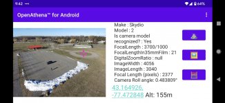
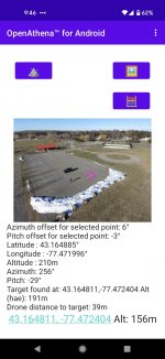
I'm the developer of OpenAthena, a free and open source UAS geodesy platform which allows common drones (including Skydio models) to spot precise geodetic locations on Earth, letting them complete their mission faster and with better accuracy:

This solves a common challenge with commercial users of UAS's, where they know where they are but have trouble precisely locating anything they're looking at on the ground.
With OpenAthena, a novel technique is introduced whereby a terrain-raycast can be performed from any pixel of a drone image towards terrain as represented by a Digital Elevation Model. This allows common drones to spot ground locations at any point in their images, greatly enhancing their ability to do useful work.

The app is free and is available on iOS and Android. Digital Elevation Model files necessary for use of the software are easily and freely obtainable here.
I'm seeking this community's feedback on how we can help you solve common challenges encountered during commercial use of drones. My email is [email protected], and I'd love to hear more about your thoughts and questions about the software.
-Matthew
I'm the developer of OpenAthena, a free and open source UAS geodesy platform which allows common drones (including Skydio models) to spot precise geodetic locations on Earth, letting them complete their mission faster and with better accuracy:

This solves a common challenge with commercial users of UAS's, where they know where they are but have trouble precisely locating anything they're looking at on the ground.
With OpenAthena, a novel technique is introduced whereby a terrain-raycast can be performed from any pixel of a drone image towards terrain as represented by a Digital Elevation Model. This allows common drones to spot ground locations at any point in their images, greatly enhancing their ability to do useful work.

The app is free and is available on iOS and Android. Digital Elevation Model files necessary for use of the software are easily and freely obtainable here.
I'm seeking this community's feedback on how we can help you solve common challenges encountered during commercial use of drones. My email is [email protected], and I'd love to hear more about your thoughts and questions about the software.
-Matthew


