Welcome to SkydioPilots.com
Sign up and join the discussion!
Sign up

Looking for a professional pilot to capture a grid of facade images in San Francisco in a tight area

Ori

New member
Joined
May 18, 2021
Messages
2
Reaction score
0
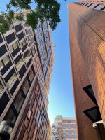
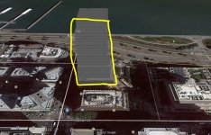
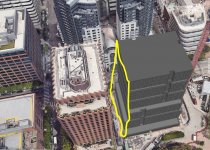
This facade has another high rise parallel and 15 feet away from it, so the pilot needs to fly in a 15 feet urban canyon, 20 stories high. See image. We need to scan the building on the left side.

The grid needs to be documented, so any line of images should correspond to a specific level, and the images should be saved in a separate folders, so images can be located on the building elevation.

Skydio X2 is preferred, but Skydio 2 may do.

Demonstrated experience is required. Crashes are out of the question.

Thanks,

Ori Aphek
[email protected]
 

Attachments

  • WhatsApp Image 2021-05-10 at 22.04.34.jpeg
    WhatsApp Image 2021-05-10 at 22.04.34.jpeg
    370 KB · Views: 3
If you are capable of doing so, take a snapshot of Kittyhawk at this location so the pilot can see what exactly is required to fly there?
 
Please see images attached. This is a newly built mid-rise, so it doesn't appear in Google Earth or alike. We added its 3D model to you can see its position relative to its surrounding. You can see it in the three images marked in yellow: a synthetic image of the building stand alone, the building with the adjacent building which causes the complexity, and the Google Map with a pin on the image and a yellow stripe marking the facade to be captured.
 

Attachments

  • OneStuartLaneFacade without other buildings.JPG
    OneStuartLaneFacade without other buildings.JPG
    196.6 KB · Views: 2
  • OneStuartLaneFacade with building in front.JPG
    OneStuartLaneFacade with building in front.JPG
    230.9 KB · Views: 2
  • Building location on 75 Howard St., San Francisco.JPG
    Building location on 75 Howard St., San Francisco.JPG
    302.7 KB · Views: 2
Okay, that's a non-controlled airspace and a 20 story building is beneath the 400 foot ceiling for drone flights, so it should be easy to get what you want.

I'd recommend reaching out to your local DronePro through the FAA portal (https://www.faasafety.gov/FAASTApp/directory/default.aspx?statecd=CA) and ask for a Part 107 certified pilot.

It should be fairly easy to get what you want since you don't need a lot of clearances. They'll also be more knowledgeable of local laws. Make sure they have a Part 107 license, not just flying recreationally so you can use your footage in whatever commercial setting you want (assuming it's a real estate demo). If you want drone flights indoors, you may still want the 107 if you want to show off the ammenities.
 

New Posts

Members online

No members online now.

Forum statistics

Threads
1,600
Messages
12,368
Members
2,363
Latest member
ViktorSinatorov0fup