Welcome to SkydioPilots.com
Sign up and join the discussion!
Sign up

Why are there so few mapping & scanning examples captured with Skydio consumer & enterprise drones posted online?

LaunchedPix

Active member
Joined
Dec 5, 2020
Messages
38
Reaction score
28
For some time now I have wondered why there are so few samples/examples of maps and 3d models captured using Skydio drones that are posted/shared on-line.

It has clearly been an area of focus for Skydio, particularly in developing their enterprise market. Even with that, there are still only perhaps a dozen or so different captured subjects/scenes that I have seen them share online.

I'm a recreational drone pilot / hobbyist. I've flown probably 30 mapping and scanning missions in the year I've had my Skydio2. These flights have have been in both easy and difficult environments (where the Skydio2 is particularly useful). I typically use a mix of DroneDeploy and manual piloting for image capture and typically process the images at home using my computer. I've shared several of those scans on-line via Instagram and YouTube. (YouTube Link)

I often look on-line for examples shared by other hobbyists and professionals and each time seem to only find only the same handful of 3D scans posted by Skydio's marketing team. Why is this?

I know the enterprise skills and 3D scan are too expensive for me to use as a hobbyist, but presumably some professionals buy/use them and some other hobbyists play with mapping & 3D scanning using the other available tools.

So why the lack of posts online by people doing this? Thoughts anyone?

 
I think the reason behind or of the fact is that this is not a hardware topic.

This is more about the software.

You can find more references and use cases from software companies.

Here is one of them and If you are also interested in the community of 3d mapping or facade, you must read it:

 
Might be because it has the perception of being enterprise level and out of the reach of most folks. If they research they can find out how to do it for free using Drone Deploy, etc.

I do see them from time to time on Instagram via the Skydio hashtag like this cool one of a stranded ship:


Swipe a couple times to see the video.
 
  • Like
Reactions: Ridefreak
I think the reason behind or of the fact is that this is not a hardware topic.

This is more about the software.

You can find more references and use cases from software companies.

Here is one of them and If you are also interested in the community of 3d mapping or facade, you must read it:

I certainly agree that software is a requirement to map & model and I would add that the desire to work on a computer to process the imagery has limited appeal to lots of drone pilots.

Part of the point of my initial question (that I may not have expressed well enough) is that the majority of mapping and modeling I see is advertising from the companies selling the hardware and software or the services to do it rather than from individuals doing it.

I agree that it's not (entirely) a hardware topic. But hardware is a factor. Mapping and modeling can be done with most any drone but just like any task, the capabilities of the tools make some jobs easier and others harder.

Thanks for sharing your input & thoughts.
 
  • Like
Reactions: Sky Cyclist
Might be because it has the perception of being enterprise level and out of the reach of most folks. If they research they can find out how to do it for free using Drone Deploy, etc.

I do see them from time to time on Instagram via the Skydio hashtag like this cool one of a stranded ship:


Swipe a couple times to see the video.
Nicely and concisely stated. I agree that's probably a substantial factor. Also, I hadn't seen that example you pointed out. Thanks!
 
  • Like
Reactions: RiverEagle
For some time now I have wondered why there are so few samples/examples of maps and 3d models captured using Skydio drones that are posted/shared on-line.

It has clearly been an area of focus for Skydio, particularly in developing their enterprise market. Even with that, there are still only perhaps a dozen or so different captured subjects/scenes that I have seen them share online.

I'm a recreational drone pilot / hobbyist. I've flown probably 30 mapping and scanning missions in the year I've had my Skydio2. These flights have have been in both easy and difficult environments (where the Skydio2 is particularly useful). I typically use a mix of DroneDeploy and manual piloting for image capture and typically process the images at home using my computer. I've shared several of those scans on-line via Instagram and YouTube. (YouTube Link)

I often look on-line for examples shared by other hobbyists and professionals and each time seem to only find only the same handful of 3D scans posted by Skydio's marketing team. Why is this?

I know the enterprise skills and 3D scan are too expensive for me to use as a hobbyist, but presumably some professionals buy/use them and some other hobbyists play with mapping & 3D scanning using the other available tools.

So why the lack of posts online by people doing this? Thoughts anyone?

@LaunchedPix I have an answer for you, and a solution. If interested, shoot me an e-mail [email protected] | It just landed me a contract with the largest film franchise in history (NDA); hence why if there are others out there doing this, we don't want to share our secrets ;). I'm going to be avenging my prior mapping methods and will be doing the entire model MANUALLY. Have a look at some of my recent models, in which every photo/angle/orientation and flight was taken manually.
 
Last edited:
  • Like
Reactions: BTCI
Also just like to point out that some of these big private organisations that have requirements for drone inspection - that information and data would more than likely be confidential

The company I work for has just started dabbling with Skydio 3d Scans in Australia on a live gas plant for the biggest oil and gas company in the country

I've found that instead of manually flying something to inspect it, just creating a 3d scan mission and automating everything, but not necessarily making a model out of the photos is actually the best and quickest way to capture what is required for inspection

The post processing of the photogrammetry software is super time consuming too
 
  • Like
Reactions: KAPture3Designs
Also just like to point out that some of these big private organisations that have requirements for drone inspection - that information and data would more than likely be confidential

The company I work for has just started dabbling with Skydio 3d Scans in Australia on a live gas plant for the biggest oil and gas company in the country

I've found that instead of manually flying something to inspect it, just creating a 3d scan mission and automating everything, but not necessarily making a model out of the photos is actually the best and quickest way to capture what is required for inspection

The post processing of the photogrammetry software is super time consuming too
Since for inspection missions the task is essentially to image every surface of an object/structure in sufficient detail it's probably hard to do better than 3D scan. Ensuring full coverage and spatially orienting / locating each image to the object (to make sense if the piles of data you capture) is also key and I believe it's handled through 3D scan. (Though I've never used it). Inspecting captured images rather than 3D models also makes sense because the models essentially always have some errors. I understand the proprietary nature of the professional work product from these inspections. That's long winded but essentially I fully agree with your comments.

It seems to me though that the application of 3D scanning with drones (using Skydios 3D scan) or other approaches to create 3D models offers so much capability beyond inspections for modeling, archiving and visualizing the world, that I'm just still surprised I don't see more applications of it today. Maybe the apparent lack of use of this technology for these other uses, and the focus on inspections, simply comes down to the economics in that there is money currently backing inspections.
Thanks for your comments. Much appreciated!
 
Also just like to point out that some of these big private organisations that have requirements for drone inspection - that information and data would more than likely be confidential

The company I work for has just started dabbling with Skydio 3d Scans in Australia on a live gas plant for the biggest oil and gas company in the country

I've found that instead of manually flying something to inspect it, just creating a 3d scan mission and automating everything, but not necessarily making a model out of the photos is actually the best and quickest way to capture what is required for inspection

The post processing of the photogrammetry software is super time consuming too
I couldn't agree more with you on that, I just happen to luckily have connections at a lot of these processing companies popping up so I figure why not. I couldn't justify paying something like PIX4D, much like you it sounds, after paying for the software. Big business and confidential data? Absolutely.
 
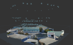
And yes, very tedious but I've found a rhythm with my EVO II PRO in conjunction with SkyDio. Due to its 35mm equivalent of 21mm, you really have to use VERY (88%+) highly overlap and often fly less than a meter of the area, per the attached.
 

Attachments

  • SHOAL_CAM_LOCATIONS.png
    SHOAL_CAM_LOCATIONS.png
    706.6 KB · Views: 14
And yes, very tedious but I've found a rhythm with my EVO II PRO in conjunction with SkyDio. Due to its 35mm equivalent of 21mm, you really have to use VERY (88%+) highly overlap and often fly less than a meter of the area, per the attached.
Thanks for posting your examples. I am looking into software options for my Skydios and it is great to see what other people are doing. I really need to get some experience in this area. I am surprised to hear you are flying manually. I guess if you do enough of these you develop that rhythm you mentioned. What program do you use for stitching? I am considering 3D Scan and DroneDeploy, so I can get the automated collection, 360 walkthrough, and stitching capability for radiometric thermal images (Autel Evo Dual R for that). The cost is a factor, as I would need research money or to get my employer to buy the licenses. It seems like you have worked out a method for getting quality deliverables. Once I get get this down, I would like to be able to do something similar to yourself. Awesome to see you are rolling with this.
 
  • Like
Reactions: KAPture3Designs

New Posts

Members online

No members online now.

Forum statistics

Threads
1,646
Messages
12,588
Members
2,495
Latest member
Robsm