- Joined
- Dec 5, 2020
- Messages
- 38
- Reaction score
- 28
For some time now I have wondered why there are so few samples/examples of maps and 3d models captured using Skydio drones that are posted/shared on-line.
It has clearly been an area of focus for Skydio, particularly in developing their enterprise market. Even with that, there are still only perhaps a dozen or so different captured subjects/scenes that I have seen them share online.
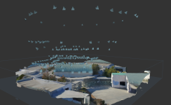
I'm a recreational drone pilot / hobbyist. I've flown probably 30 mapping and scanning missions in the year I've had my Skydio2. These flights have have been in both easy and difficult environments (where the Skydio2 is particularly useful). I typically use a mix of DroneDeploy and manual piloting for image capture and typically process the images at home using my computer. I've shared several of those scans on-line via Instagram and YouTube. (YouTube Link)
I often look on-line for examples shared by other hobbyists and professionals and each time seem to only find only the same handful of 3D scans posted by Skydio's marketing team. Why is this?
I know the enterprise skills and 3D scan are too expensive for me to use as a hobbyist, but presumably some professionals buy/use them and some other hobbyists play with mapping & 3D scanning using the other available tools.
So why the lack of posts online by people doing this? Thoughts anyone?
It has clearly been an area of focus for Skydio, particularly in developing their enterprise market. Even with that, there are still only perhaps a dozen or so different captured subjects/scenes that I have seen them share online.
I'm a recreational drone pilot / hobbyist. I've flown probably 30 mapping and scanning missions in the year I've had my Skydio2. These flights have have been in both easy and difficult environments (where the Skydio2 is particularly useful). I typically use a mix of DroneDeploy and manual piloting for image capture and typically process the images at home using my computer. I've shared several of those scans on-line via Instagram and YouTube. (YouTube Link)
I often look on-line for examples shared by other hobbyists and professionals and each time seem to only find only the same handful of 3D scans posted by Skydio's marketing team. Why is this?
I know the enterprise skills and 3D scan are too expensive for me to use as a hobbyist, but presumably some professionals buy/use them and some other hobbyists play with mapping & 3D scanning using the other available tools.
So why the lack of posts online by people doing this? Thoughts anyone?


") . I'm going to be avenging my prior mapping methods and will be doing the entire model MANUALLY. Have a look at some of my recent models, in which every photo/angle/orientation and flight was taken manually.
. I'm going to be avenging my prior mapping methods and will be doing the entire model MANUALLY. Have a look at some of my recent models, in which every photo/angle/orientation and flight was taken manually.