- Joined
- Jul 20, 2022
- Messages
- 1
- Reaction score
- 0
Hey hey all, So wanted to open up some discussion about the real accuracy of 3D Scan software.
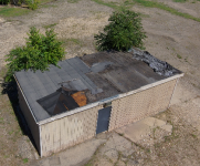
What I have found is that we scanned a small lot with a storage shed on it to get some measurements with the Skydio 2+ enterprise and scanned the shed with a Leica RTC360 terrestrial laser scanner.
We use the RTC a lot and I knew the Skydio was not going to be as accurate but wanted to see how close it could get. I mean reading what the company states it is or could be survey grade in the cm range.
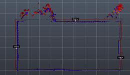
Well the shed is 31' x 14.5' and in that short distance there is an 7.7" east, 7.2" north and 6.3" west discrepancy in wall positions.
Now grant it we did not use GSPs (Which we will try next) we wanted to see what it did on its own. I am hoping that the putting it on control will fix this but wanted to see what everyone else was experiencing and just start up a discussion on best practice's.
I processed on both WebODM and Pix4d Mapper and both are virtually exact. The average GSD is 0.36cm/0.14" per Pix4D... That's 3.6mm So at an average of 3x's that is 10.8mm so basically 1cm supposed accuracy if I am doing my math right haaa haa
We use a lot of terrestrial, mobile and drones (other than the Skydio) to do our everyday scanning and know the tricks of the trade to get accuracy with their data but wanted to implement the Skydio of tight places and interiors. If it isn't more accurate than that it is basically only good for observation pic's. Far from what I was sold on.
So anyone out there up to a conversation to explore?
I just want to see if anyone has figured a way to get this tighter or has any ideas on processing
What I have found is that we scanned a small lot with a storage shed on it to get some measurements with the Skydio 2+ enterprise and scanned the shed with a Leica RTC360 terrestrial laser scanner.
We use the RTC a lot and I knew the Skydio was not going to be as accurate but wanted to see how close it could get. I mean reading what the company states it is or could be survey grade in the cm range.
Well the shed is 31' x 14.5' and in that short distance there is an 7.7" east, 7.2" north and 6.3" west discrepancy in wall positions.
Now grant it we did not use GSPs (Which we will try next) we wanted to see what it did on its own. I am hoping that the putting it on control will fix this but wanted to see what everyone else was experiencing and just start up a discussion on best practice's.
I processed on both WebODM and Pix4d Mapper and both are virtually exact. The average GSD is 0.36cm/0.14" per Pix4D... That's 3.6mm So at an average of 3x's that is 10.8mm so basically 1cm supposed accuracy if I am doing my math right haaa haa
We use a lot of terrestrial, mobile and drones (other than the Skydio) to do our everyday scanning and know the tricks of the trade to get accuracy with their data but wanted to implement the Skydio of tight places and interiors. If it isn't more accurate than that it is basically only good for observation pic's. Far from what I was sold on.
So anyone out there up to a conversation to explore?
I just want to see if anyone has figured a way to get this tighter or has any ideas on processing