Welcome to SkydioPilots.com
Sign up and join the discussion!
Sign up

Anyone making orthomosaics?

engineer2loggie

New member
Joined
Feb 14, 2022
Messages
3
Reaction score
0
I currently have a Phantom 4 Pro v2. Had some really bad geofencing issues this weekend while performing some mapping missions. I use Webodm for processing and have never had an issue with the results.
I do NOT plan on paying $2900 for any 3D scan for the time being.

I was looking at a Skydio 2+ as a backup for my orthomosaic jobs, but I'm a little concerned about the megapixel difference between the P4P v2 and the Skydio 2+. Mainly I want to avoid the geofencing garbage forced on me when flying, but quality matters, of course.

Some questions that pop in my head:

- Are your orthomosaics more limited to lower altitudes?

- Does anyone have any results they can share?

- Any issues with android or IOS when flying with 3rd party mission planning apps?

Thanks for anyone's input.
 
I would go here to solve your problems: No Limit Drones

The Phantom 4 Pro V2 has capabilities that are unequaled for the type of work you are doing, including the mechanical shutter, range and compatibility with the various mapping softwares.

I love my Skydio 2 but it could never replace what a Phantom 4 Pro can do.
 
  • Like
Reactions: TonyPHX
Drone Deploy wtih Skydio 2 can in theory do this, but I have not tested this myself. I am currently in my trial phase of Drone Deploy and only been using it with a different brand drone. I am told with Drone Deploy I can use Skydio 2 with my iphone, so will give that a try later today if the clouds move along.
 
Drone Deploy wtih Skydio 2 can in theory do this, but I have not tested this myself. I am currently in my trial phase of Drone Deploy and only been using it with a different brand drone. I am told with Drone Deploy I can use Skydio 2 with my iphone, so will give that a try later today if the clouds move along.
TonyPHX,

I appreciate you taking a gander at it. We process all orthomosaics in-house and I know that 12MP is our bare minimum requirement, but I have never used anything other than the P4Pv2 and am curious what the results are. Unless I'm looking in the wrong place, I dont see much in the way of examples online with the Skydio 2/2+
 
I would go here to solve your problems: No Limit Drones

The Phantom 4 Pro V2 has capabilities that are unequaled for the type of work you are doing, including the mechanical shutter, range and compatibility with the various mapping softwares.

I love my Skydio 2 but it could never replace what a Phantom 4 Pro can do.
Saladshooter - Have you used this NFZ removal on a UAS of yours?

...Plus...I'm not really looking to fully replace the P4Pv2. More of adding to the fleet for different purposes. the Skydio 2+ will really compliment some of the real estate shots I do. BUT... It sure would be used in the case of a problematic situation like I had this last weekend...
The problems arose this last weekend when I was using a 3rd party app like DroneDeploy with the P4Pv2 in an area that LAANC shows is obviously clear, and then I cant get the P4Pv2 to start up during the initialization process without first having to start GSPro 4, going through the acceptance and acknowledgment that there is a heliport a mile away, then opening DD, and then being able to take off.
Battery needs change out; swap out battery; repeat process; change waypoint start point in DD, and ... repeat 3 more times....
 
Saladshooter - Have you used this NFZ removal on a UAS of yours?
I have not used NFZ myself but they have a great reputation in the community. Their unlocks are well regarded and used by many, as you will find if you poke around the various forums. My area doesn't have flight restrictions to deal with and I have a few drones I can fly that don't have geofencing baked in.

The Skydio 2 was only recently added to DroneDeploy which is why you are having problems finding online examples. It would be good for mapping at lower altitudes because of its great obstacle avoidance. The avoidance isn't perfect so you would still have to be on the lookout for small bare branches and thin wires

I would only consider a Skydio 2+ because of the improved transmission system. The short range of the original S2 is very limiting. The controller is a bit toylike though it works pretty well. Skydio does wring every ounce of clarity and resolution out of the camera so I think it would serve you fine in most situations.
 
Ok, tried Drone Deploy today with the S2+. I could not connect to the drone. I assumed perhaps wrongly that Drone Deploy would not think the difference between the S2 and 2+ would matter. I ended up giving up.
 
I am going to try one more time this am. Darn airfield club is having a meeting now. : )
 
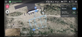
Ok, DD works with the Skydio 2+. My issue: #1, my trial account had expired... #2, created a new account. But Skydio app has to be running and the DD app it appears. DD connects. It flew the mapping mission, and maybe I'm just used to mapping with other style drones, but it flew the grid like a drunken sailor. So it kind of mentally stressed me, lol, BUT - the images appear to be perfectly acceptable. I did it at 200 feet and again at 100 feet. I will post an ortho if / when time permits to dump the card and stitch it.
 
IMG_8708.jpg

Here is what I meant by "flew like a drunken sailor", you can see in DD that the S2 just didn't really care about sticking too close to the planned path. Pictures though still have coverage and overap I requested, so other than feeling different, it was not a problem on the actual ortho.
 
@engineer2loggie, FWIW you don't necessarily need DD to do orthomosaics and therefore also don't need the controller. I'm just getting in to this (both flying the S2+ and mapping in general) so take it with a huge grain of salt, but, I did just yesterday do a flight with the camera pointing nadir and just manually waypointing to cover an area while capturing 4K 60fps. I extracted images from the video frames and fed those into OpenDroneMap and was able to get results.

Are they good results? I think that's pretty dependent on the parameters you set for ODM and I'm very much a noob there. I just tried cranking everything way up, we'll see how long it takes to process (this is locally - my last try took 2h15m)

Anyway point being it's possible at least in principle to capture the imagery with an S2+ for the purposes of mapping without using DD/controller, and I'm doing that mostly at this point to see what kind of quality I'm able to get with the hardware I currently have and without a DD subscription. We'll see..

Does the free DD account let you just upload images? If so I'll give that a try. I'm quite interested in comparing DD results with what I can get with ODM so if anyone's up for running the images through DD (happy to Venmo you some amount to compensate) then I'd be interested.

@TonyPHX did you ever generate that map? And OP what did you conclude?
I did not get around to it. Maps of larger areas take quite a long time. I really think that for anything larger than an acre you simply must have automation software though. I don't think anybody is going to accept your manually flown deliverables.
 
Saladshooter - Have you used this NFZ removal on a UAS of yours?

...Plus...I'm not really looking to fully replace the P4Pv2. More of adding to the fleet for different purposes. the Skydio 2+ will really compliment some of the real estate shots I do. BUT... It sure would be used in the case of a problematic situation like I had this last weekend...
The problems arose this last weekend when I was using a 3rd party app like DroneDeploy with the P4Pv2 in an area that LAANC shows is obviously clear, and then I cant get the P4Pv2 to start up during the initialization process without first having to start GSPro 4, going through the acceptance and acknowledgment that there is a heliport a mile away, then opening DD, and then being able to take off.
Battery needs change out; swap out battery; repeat process; change waypoint start point in DD, and ... repeat 3 more times....
Late in reply... I use both NLD and DH (Drone Hacks).
They both offer a full featured hack for P4Pv2.
I mainly use DH for all the newer Mavic series, and NLD for P4P and I2 crafts... mainly because NLD had product for some time before DH.

All works great, no issues and completely removes the hard NFZ stops. You get the older message at times asking for you to take responsibility - check box.

Whether you buy an S2+ (I have a S2) or not, removing NFZ is quick and easy... and it's on the Craft so it works with any 3rd Party software.
 
Last edited:
Just my opinion, the 1" sensor & mechanical shutter of the P4Pv2 and Zenmuse X4S (same camera) are hard to beat for Ortho & 3D modeling. Plus the flight software available for the P4Pv2 is plentiful.

The S2 wouldn't be my choice for this arena... although I think for it's intended scope it's outstanding!
 
For what it’s worth, I tested my Skydio 2 with Drone Deploy a while back and it ran the mission and collected the photos just fine. I processed the photos into a 2D ortho and 3D mesh using Pix4D and the output at least looked decent. I did not have any check points or ground control points during the flight, though, so I can’t speak to the positional accuracy of the Skydio.

My primary machine is still my Phantom 4 Pro. I have run into the flight restricted zone issue on several occasions…just last week, in fact, and within a couple areas that weren’t even controlled airspace…but I have never let it prevent me from getting my work done. I just go through DJI’s Fly Safe zone unlock process.
 

New Posts

Members online

No members online now.

Forum statistics

Threads
1,646
Messages
12,588
Members
2,495
Latest member
Robsm