Welcome to SkydioPilots.com
Sign up and join the discussion!
Sign up

Skydio photos needed

t3l3tubie

Member
Joined
May 13, 2022
Messages
8
Reaction score
3
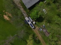
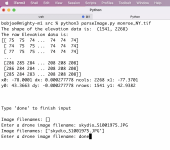
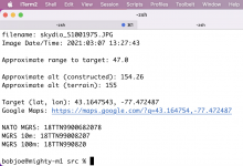
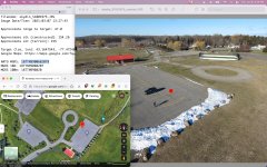
I'm developing some opensource software that takes metadata from drone still-images and uses it to find the spot it's looking at on the ground

Examples (DJI images):
pretty_good.jpg

proof_of_concept_small.jpg
(I've marked the center of each image with a red dot for demonstrating the concept. As you can see, the location derived is almost in exactly the same place as the center of the image)

I'm looking for example photos taken by Skydio craft to test with. Ideally, a certain building, feature, or other locate-able spot should be in center of the frame, but any images will do as long as they have their original metadata

-Matthew
 
Last edited:

t3l3tubie

Member
Joined
May 13, 2022
Messages
8
Reaction score
3
Great photo, just what I'm looking for

Here's the command I ran to get the terrain data for Huntington County IN:
eio_clip.jpg


Here's what OpenAthena found with your image:
open_athena_skydio089.jpg

Here is the XMP data of your image:
xmp_data.jpg

I discovered a bug with how I handle coordinates and the EXIF make tag

Thanks for the example photo, really helps a lot for development
 
  • Like
Reactions: somewhereinusa

t3l3tubie

Member
Joined
May 13, 2022
Messages
8
Reaction score
3
Looking to get more test images with Skydio craft

Software is now capable of automatic usage of photos taken by Skydio craft, but I'd like to have more test photos to make sure it works for all models and edge cases

Check it out free @ OpenAthena.com
 

t3l3tubie

Member
Joined
May 13, 2022
Messages
8
Reaction score
3
Ok, so they changed the metadata format for newer firmware version, OpenAthena doesn't work with newer versions I guess

Looking into it now...
 

LaunchedPix

Active member
Joined
Dec 5, 2020
Messages
37
Reaction score
27
Awesome, this is just what I'm looking for!

Looking through the images now
FYI...nA few of the folders might contain extracted video frames. If the images are 3840x2160 then those are video frames.
 

LaunchedPix

Active member
Joined
Dec 5, 2020
Messages
37
Reaction score
27
Looking to get more test images with Skydio craft

Software is now capable of automatic usage of photos taken by Skydio craft, but I'd like to have more test photos to make sure it works for all models and edge cases

Check it out free @ OpenAthena.com
I sure hope this technology can and will be applied to search & rescue applications. A recent PiXL drone show video/podcast mentioned the challenges in scanning a scene with a drone to do search & rescue operations. It's apparently & understandably challenging to keep track of the ground that was already scanned real time with the drone camera to efficiently search/scour the terrain. It seems like basically what your doing could be adapted for this lifesaving use case.
 

t3l3tubie

Member
Joined
May 13, 2022
Messages
8
Reaction score
3
I just pushed out an update, OpenAthena is now working with the images from your "Walk in the Park" video. I think this should also be the case with still images taken by the latest firmware, but I'm not sure yet

Thanks @LaunchedPix , yeah search and rescue (SAR) is a great application of this software. Terrain matches are quick to run and surprisingly accurate, I hope this technique will be used more frequently. Hopefully this software will help save lives
 

Attachments

  • Screen Shot 2022-06-09 at 4.16.34 PM.png
    Screen Shot 2022-06-09 at 4.16.34 PM.png
    20.9 KB · Views: 5
  • Screen Shot 2022-06-09 at 4.17.53 PM.png
    Screen Shot 2022-06-09 at 4.17.53 PM.png
    612.9 KB · Views: 4
  • Screen Shot 2022-06-09 at 4.18.10 PM.png
    Screen Shot 2022-06-09 at 4.18.10 PM.png
    218.8 KB · Views: 6
  • oa_skydio_screenshot_compressed.jpg
    oa_skydio_screenshot_compressed.jpg
    966.8 KB · Views: 5
  • Like
Reactions: LaunchedPix

LaunchedPix

Active member
Joined
Dec 5, 2020
Messages
37
Reaction score
27
I just pushed out an update, OpenAthena is now working with the images from your "Walk in the Park" video. I think this should also be the case with still images taken by the latest firmware, but I'm not sure yet

Thanks @LaunchedPix , yeah search and rescue (SAR) is a great application of this software. Terrain matches are quick to run and surprisingly accurate, I hope this technique will be used more frequently. Hopefully this software will help save lives
That looks pretty cool & useful!
 

New Posts

Members online

No members online now.

Forum statistics

Threads
1,496
Messages
11,807
Members
2,112
Latest member
MitchS24